Site Scan for ArcGIS - LE

Site Scan for ArcGIS - LE

Flight Planning

Details about Site Scan for ArcGIS

  • Released
  • Updated
  • iOS Version
  • Age Rating
  • Size
  • Devices
  • Languages
  • November 2, 2018
  • October 2, 2024
  • 14.3+
  • 4+
  • 374.83MB
  • iPad
  • English
    Japanese
    Portuguese
    Show more

Features

Developer of Site Scan for ArcGIS

🙌5
Ratings
🗣❌ unsupported
Your locale
🖼️Download
Icons↘︎

Version History of Site Scan for ArcGIS

4.3.1

April 26, 2022

- DJI M300RTK support with P1 camera - Flight speed setting - Define mission area from polygon - iOS 15 Support - Retire support for H520-G drone and Zenmuse Z30 camera - Additional bug fixes

More

4.1.3

April 12, 2021

- Bug fix: ArcGIS layers not loading

4.1.2

March 29, 2021

- Connect Phantom 4 RTK to network correction services - Display and Unlock DJI No-Fly Zones - AirspaceLink integration (USA Only) - Improved offline basemap download experience - Bug fix: Corridor scan skipping photos - Additional bug fixes

More

4.1

October 26, 2020

- Terrain Follow - Geospatial Log Export for use in ArcGIS Pro Full Motion Video - Phantom 4 RTK support - ArcGIS QuickCapture integration - Updated flight settings terminology - New logo - Groups and search function while adding ArcGIS Layers - Bug fix: Mission timeout during multibattery mission - Additional bug fixes

More

4.0.2

September 14, 2020

- Map SDK update

4.0.1

June 30, 2020

- Custom lens focal length support (advanced setting) - ArcGIS QuickCapture & ArcGIS Survey123 location sharing (Beta) - Bug fixes including Resuming Multi-Battery Mission fix

More

4.0

April 2, 2020

- The Corridor Scan flight mode makes it easy to map linear sites by creating flights directly over, or alongside, the corridor. - ArcGIS Online integration allows users to import maps and layers from their account. - Basemaps now provided by Esri. - 3D Flight Plan viewer for all flight modes.

More

1.7

November 27, 2019

- H520-G Video capture in autonomous flight modes. - Vertical Scan: Fixed and Variable slope modes allowing to safely and accurately capture complex structures. - 3DR H520-G Thermal camera support in Inspect mode. - Area Survey improvement: aircraft will always fly nose-forward which improves processed results for drones equipped with rolling-shutter cameras. - Minor improvements and fixes.

More

1.6

September 23, 2019

- iOS 13 support - Support for DJI M200/210/210RTK V2 drones with X7, X5s, X4s cameras - 2D and 3D flight planning for Vertical and Perimeter scan flight modes Includes improvements and fixes such as battery & flight time estimates for all drones, H520-G Over-the-air updates fix, improved camera setting for optimal accuracy.

More

1.5

July 1, 2019

- Support for the DJI Zenmuse X7 camera (compatible with Inspire 2 drone) - Improvements to the Yuneec E90 camera processing - H520-G stability improvements - Vertical Scan flight planning with multiple vertices - GCP icon displayed next to ortho layers - More accurate battery & flight time estimates for all drones

More

Price History of Site Scan for ArcGIS

Description of Site Scan for ArcGIS

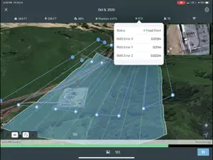
Site Scan for ArcGIS Limited Edition (LE) is a simplified version of the Site Scan for ArcGIS Flight Planning App, built for ArcGIS Drone2Map users, that allows you to easily capture rich imagery using advanced drone flights. Use your favorite maps and layers from ArcGIS Online to plan accurate missions in Site Scan for ArcGIS - LE. Process your images in ArcGIS Drone2Map or an alternative stitching software to create 2D and 3D data products. Experienced pilots can use Terrain Follow, which enhances imagery quality by adjusting the drone's height to follow the terrain. Choose from a variety of flight modes tailored to the type of site being scanned, and the app will automatically define the optimal flight path and allow you to preview it in 2D or 3D. The app automatically conducts aircraft checks and executes the flight. Long flights are automatically split, allowing you to change your drone’s battery and resume where you left off. Compatibility: - Requires compatible drone: DJI P4 Advanced, DJI P4P, DJI P4P V2, DJI P4 RTK, Mavic Pro, Mavic 2 Pro, M200 series, M200 series V2, Inspire 2, DJI M300RTK. - Requires ArcGIS Drone2Map or other image processing software to create 2D and 3D data products - ArcGIS Online subscription required
Show less

Site Scan for ArcGIS: FAQ

Is the software for Site Scan for ArcGIS compatible with iPads?

Yes, Site Scan for ArcGIS is optimized for iPad devices.

Who made the Site Scan for ArcGIS app?

The app was developed by ESRI.

What is the minimum iOS version for the Site Scan for ArcGIS app?

Your iOS device must be running iOS 14.3 or above.

What user rating does Site Scan for ArcGIS have?

Users have overwhelmingly positive things to say about Site Scan for ArcGIS, as evidenced by its stellar rating of 4.2 out of 5.

What genre of app is Site Scan for ArcGIS?

The App Category Of The Site Scan For Arcgis App Is Business.

What is the recent version of Site Scan for ArcGIS?

4.3.1 is the newly released version of the Site Scan for ArcGIS app.

When was the last Site Scan for ArcGIS update?

The latest update for Site Scan for ArcGIS was released on October 2, 2024.

When was Site Scan for ArcGIS first released?

The app was initially released on February 5, 2023.

What content advisory rating is assigned to the Site Scan for ArcGIS app?

Designed for children, contains no adult material.

What languages is Site Scan for ArcGIS available in?

Currently, the Site Scan for ArcGIS app supports the following languages: English, Japanese, Portuguese and 1 more.

Can I access Site Scan for ArcGIS via Apple Arcade's subscription service?

No, Site Scan for ArcGIS is not on Apple Arcade.

Is Site Scan for ArcGIS equipped with in-app purchases?

No, Site Scan for ArcGIS does not feature in-app purchases for users.

Does Site Scan for ArcGIS offer compatibility with Apple Vision Pro?

No, Site Scan for ArcGIS does not offer compatibility with Apple Vision Pro.

Does Site Scan for ArcGIS incorporate ads within the app?

No, Site Scan for ArcGIS does not incorporate ads within the app.

Screenshot of Site Scan for ArcGIS

Site Scan for ArcGIS - LE screenshot #1 for iPad
Site Scan for ArcGIS - LE screenshot #2 for iPad
Site Scan for ArcGIS - LE screenshot #3 for iPad
Site Scan for ArcGIS - LE screenshot #4 for iPad
Site Scan for ArcGIS - LE screenshot #5 for iPad
Site Scan for ArcGIS - LE screenshot #6 for iPad
Site Scan for ArcGIS - LE screenshot #7 for iPad
ipad

Alternatives to Site Scan for ArcGIS

More Applications by ESRI

Reviews of Site Scan for ArcGIS

Leave a Review Site Scan for ArcGIS
  • New version crashes

    I just downloaded and it crashes when connected to controller, M300 rtk. Saw a new post on series site from today that said the same thing. Please fix, love the app.
  • Free Version Crashes

    This seems as thoughThey designed this app to crash so that you will be forced to use their paid version. This app does not allow you to draw boundaries and when you try it crashes immediately. Conceptually this seems like a very beneficial app to have if you are a mapping professionalsBut it’s obviously not their goal to be just one of the mini apps in your application repertoire.
    Show less