Free
⭐️3.4 / 5
Rating
🙌23
Ratings
📼3 scs
Content
📦w/o updates
Updates frequency
🗣❌ unsupported
Your locale
- Versions
- Price History
- Description
- FAQ
All Versions of OEGames Land Navigation
1.0
March 9, 2020
Price History of OEGames Land Navigation
Description of OEGames Land Navigation
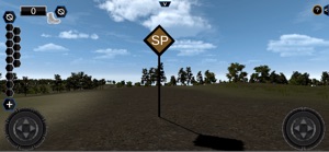
The OEGames Land Nav application is designed to allow you to practice your land navigation skills in the absence of a physical land navigation course. This application helps you exercise the objectives of:
1. Correctly plotting points.
2. Establishing your plan for completing the course.
3. Calculating distance and direction.
4. Correctly using pace count and pace beads.
OEGames Land Navigation: FAQ
Yes, OEGames Land Navigation is compatible with iPad devices.
The OEGames Land Navigation app was created by Army Training Support Center.
The minimum supported iOS version for the OEGames Land Navigation app is iOS 9.0.
The overall user rating of OEGames Land Navigation is 3.4.
The Main Genre Of The Oegames Land Navigation App Is Education.
The latest version of the OEGames Land Navigation app is 1.0.
OEGames Land Navigation rolled out its latest update on July 5, 2024.
OEGames Land Navigation originally came out on February 5, 2023.
The OEGames Land Navigation app is rated Army Training Support Center.
OEGames Land Navigation is available in English.
Sorry, OEGames Land Navigation is not on Apple Arcade.
Sorry, in-app purchases are not available for users of OEGames Land Navigation.
No, you cannot use OEGames Land Navigation with Apple Vision Pro.


