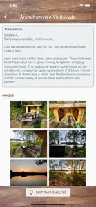
Shelter Map (Vindskyddskartan)
Get closer to nature!
Details about Shelter Map (Vindskyddskartan)
- Released
- Updated
- iOS Version
- Age Rating
- Size
- Devices
- Languages
Features
Developer of Shelter Map (Vindskyddskartan)
- Versions
- Subscription Plans
- In-App Purchases History3
- Price History
- Description
- FAQ
Version History of Shelter Map (Vindskyddskartan)
2.2.8
August 9, 2024
- Info about trails, nature areas and public transport in the vicinity of a shelter is displayed on the detail page for each shelter (when such info is available). This info is in "beta", which means it has some limitations and that it might not be 100% reliable.
More2.2.4
August 21, 2023
Improved display of GPX tracks, including better performance for large files with long tracks, and viewing of routes and waypoints.
2.2.0
May 31, 2023
You can now see if a shelter has been visited recently, i.e. if someone else has been actively using the app in the immediate vicinity of the shelter. This feature is 100% anonymous - no user information is stored and it's not possible to see who visited or the exact time of the visit. All visits are removed after 12 hours, and the feature can be turned off in the app settings.
More2.0.7
May 14, 2023
* It's now possible to filter shelters based on nearby hiking trails. * It's now possible to search for nearby shelters, within a 10 km radius from your current position. * Active filters have been moved from the map to the filter dialog (the button with 3 horizontal lines).
More2.0.5
February 10, 2023
Trails/tracks can be downloaded and displayed on the map. Custom trails can be imported from GPX files. These features are accessible via the layer button on the map.
More2.0.4
August 5, 2022
Added functionality to show GPX-files on the map, for example to display hiking trails or your own routes. Click on the "layers button" on the map to access this feature. +other minor improvements
More2.0.3
August 4, 2022
Added functionality to show GPX-files on the map, for example to display hiking trails or your own routes. Click on the "layers button" on the map to access this feature.
More2.0.2
August 1, 2022
Added functionality to show GPX-files on the map, for example to display hiking trails or your own routes. Click on the map layers button on the map to access this feature.
More1.9.4
June 29, 2022
Improved language support.
1.9.3
June 20, 2022
Improved language support.
Shelter Map (Vindskyddskartan) In-App Purchases History
$18.99
Engångsköp - gäller för evigt!
Betala en gång och använd appen för evigt!
Shelter Map (Vindskyddskartan) Subscription Plans
Prenumeration 1 månad
Inkluderar 3 dagar gratis provperiod
Prenumeration 1 år
Inkluderar 3 dagar gratis provperiod
Price History of Shelter Map (Vindskyddskartan)
Description of Shelter Map (Vindskyddskartan)
Shelter Map (Vindskyddskartan): FAQ
Is Shelter Map (Vindskyddskartan) iPad-friendly?
Yes, you can use the Shelter Map (Vindskyddskartan) app on iPad devices.
Who created the Shelter Map (Vindskyddskartan) app?
MangoData AB built the Shelter Map (Vindskyddskartan) app.
What’s the minimum iOS version needed for the Shelter Map (Vindskyddskartan) app?
The minimum iOS version for the Shelter Map (Vindskyddskartan) app is 11.0.
How do users rate the Shelter Map (Vindskyddskartan) app?
The overall user rating of Shelter Map (Vindskyddskartan) is 5.
What category is the Shelter Map (Vindskyddskartan) app?
The App Genre Of The Shelter Map (vindskyddskartan) App Is Travel.
Which version of the Shelter Map (Vindskyddskartan) app is the latest one?
The newest version of Shelter Map (Vindskyddskartan) is 2.2.8.
What is the latest Shelter Map (Vindskyddskartan) update release date?
The date of the latest Shelter Map (Vindskyddskartan) update is November 30, 2024.
What is the exact date when Shelter Map (Vindskyddskartan) came out?
Shelter Map (Vindskyddskartan) became publicly available on February 6, 2023.
What age is Shelter Map (Vindskyddskartan) appropriate for?
The content advisory rating for the Shelter Map (Vindskyddskartan) app is MangoData AB.
What are the languages available on Shelter Map (Vindskyddskartan)?
Shelter Map (Vindskyddskartan) is now available to use in English, Swedish.
Is Shelter Map (Vindskyddskartan) part of the Apple Arcade lineup of games?
Sorry, Shelter Map (Vindskyddskartan) is not part of Apple Arcade.
Is Shelter Map (Vindskyddskartan) eligible for in-app purchases?
Yes, Shelter Map (Vindskyddskartan) is eligible for in-app purchases to enrich your usage.
Is Shelter Map (Vindskyddskartan) fully compatible with Apple Vision Pro?
Unfortunately, Shelter Map (Vindskyddskartan) is not fully compatible with Apple Vision Pro.
Can I expect ads while using Shelter Map (Vindskyddskartan)?
No, you can not expect ads while using Shelter Map (Vindskyddskartan).


