AngelNav

AngelNav

Charting app made by sailors

Details about AngelNav

  • Released
  • Updated
  • iOS Version
  • Age Rating
  • Size
  • Devices
  • Languages

Features

Developer of AngelNav

🙌2
Ratings
🗣❌ unsupported
Your locale
🖼️Download
Icons↘︎

Version History of AngelNav

2.0.0

September 13, 2024

New Tides module. Tidal heights and streams for waters of the United Kingdom and Ireland

1.2.6

August 19, 2024

Fixed an issue preventing chart downloads when 24-Hour Time was set to off Improved compatibility with SignalK servers Fixed an issue with reading data from the Vesper Marine XB-8000 AIS Transponder Added compliance with iOS 18.0

More

1.2.5

June 6, 2024

Fixed an issue with the browse to chart folder function for iOS 15 users Added support for remote notifications Added a depth offset for use with incorrect NMEA data sources

More

1.2.4

May 10, 2024

Fixed an issue with satellite charts created on devices with large screens Fixed an issue with some newly purchased subscriptions showing as expired Added instructions in the user guide for using OpenSeaMap charts

More

1.2.3

April 1, 2024

Added a new Chart Finder for finding and loading charts graphically Added a chart boundaries overlay to display other available charts Added the ability to detect a GPS spoofing attack Moved the NMEA simulator to the Extras tab Fixed an issue whereby display of CPA information could sometimes cause a crash Changed waypoint and route editing so that the + button goes directly to the edit screen Fixed an issue with identifying charts that straddle the anti-meridian Added a new instrument to display true wind direction (TWD) Added the ability to import tracks Added a new Data page to delete, backup and restore data Added the ability to export a single route Added a running total column when exporting a route to a passage plan Added a filter to show only relevant AIS targets

More

1.2.2

February 15, 2024

Added remaining Imray chart folios including coverage of the Mediterranean Added new UKHO derived folios of the Atlantic islands and Atlantic coasts of Spain and Portugal Added updated coefficients of the World Magnetic Model valid until 2025 Minor user interface improvements

More

1.2.1

December 21, 2023

Added Imray charts (Caribbean folio) as a new in-app purchase Added an NMEA simulator to allow demonstration of capabilities prior to purchase Improved behaviour of recent charts menu Added setting to limit memory use for large BSB files Fixed issue with display of BSB charts with skew angles other than zero Fixed bug with satellite charts covering an area which includes the anti-meridian Improved compatibility with iOS17 Removed +/- buttons for subscription charts in store Fixed bug whereby charts sometimes do not download on a second device

More

1.2.0

September 18, 2023

A new instruments feature as an in-app purchase (displays wind, depth, heading etc if available) Three new subscription folios covering the coasts of France using charts from SHOM A new NMEA message console has been added to settings Improvements in the recording and display of tracks Additional format options for the display and entry of latitude and longitude Race wizard improvements Improved feedback for store purchases Updated for iOS 17 Updated help file

More

1.1.0

July 16, 2023

- Added a race wizard as an in-app purchase - Added a new folio covering the coasts of Belgium and the Netherlands - Added new progress bar when downloading charts - Added the ability to mark charts as favourites and filter on them in the chart list - Modified the goto button in the waypoint list to allow both goto and cancel - Added a time value to the dead reckoning chart work - Added activity indicators for incoming GPS and AIS information - Fixed occasional crash when loading a chart - Addressed crashes when loading very large NOAA charts - The zooming out limit now adjusts itself to allow viewing of the whole chart on screen - Added the ability to copy a route - Expanded instant help to include the Routes tab - Added import and export of routes - Updated the help file

More

1.0.18

July 6, 2023

Minor bug fixes

AngelNav In-App Purchases History

$1.99

UKTides 24

Tidal information for the UK and Ireland 2024

🪨 price unchanged, but purchase info updated on August 28, 2024.

🪨 price unchanged, but purchase info updated on August 11, 2024.

$4.99

Satellite charts

Ability to open satellite charts

$4.99

KAP files

Ability to open charts in KAP(BSB) format

$4.99

AIS

Display AIS information on the chart

$4.99

Instruments

Displays available boat instrument data

$4.99

GeoTIFF files

Ability to open charts in GeoTIFF format

$7.99

BITides 25

Tidal information for the UK and Ireland 2025

AngelNav Subscription Plans

UKHO AO2

UKHO Charts Folio AO2

$24.991 Year

UKHO BF1

UK Charts Folio BF1

$24.991 Year

UKHO BF8

UK Charts Folio BF8

$24.991 Year

UKHO MS3

UKHO Charts Folio MS3

$24.991 Year

UKHO MS1

UKHO Charts Folio MS1

$24.991 Year

UKHO MS2

UKHO Charts Folio MS2

$24.991 Year

UKHO BF3

UK Charts Folio BF3

$24.991 Year

Imray ID70

Charts of the Eastern Mediterranean

$69.991 Year

Imray ID40

Charts of Atlantic France, Iberia & Islands

$69.991 Year

Imray ID100

Charts of the Eastern Caribbean

$69.991 Year

Imray ID60

Charts of the Central Mediterranean

$69.991 Year

Price History of AngelNav

Description of AngelNav

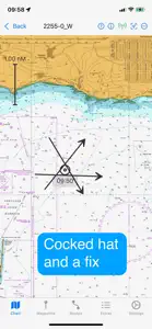
AngelNav is a brand new app for iOS developed in collaboration with Tom Cunliffe. Primarily it is a full chart plotter currently favouring raster charts, but it has many additional features including the ability to carry out traditional navigation directly on the screen. The capacity to generate classical chart work is vitally important in the event of a GPS failure, but hitherto has required pencil, plotters, and paper charts. AngelNav allows traditional techniques to be carried out using an iPad or iPhone screen instead of a paper chart. An estimated position can be plotted, position lines drawn from sighted bearings and fixes recorded. Course-to-steer diagrams are readily constructed. AngelNav can read most types of raster chart including the UKHO subscription charts, as well as KAP/BSB files and GeoTIFF files. Like its sister application for macOS, AngelPilot, it can easily create and read its own satellite charts. AngelNav can take satellite navigation data from a variety of sources, including the device's stand-alone GPS, the boat's NMEA over WiFi, and SignalK. It will also display AIS information if available. Annual subscriptions are available as in-app purchases for UKHO charts covering the whole of the UK. These are divided into 8 folios so that you can subscribe only to the charts that you need. The app is free to use in its basic form, with additional functions and charts available as in-app purchases. This allows a user to fully evaluate the app without charge, and then to purchase the features and charts required. Free features: Chart plotter (Demo chart included) Traditional navigation techniques Waypoints and Routes Track recording and display Reads navigational data Simulation mode Paid for features (in-app purchases): Open KAP/BSB files Open GeoTIFF files Open Satellite charts Display AIS targets (if AIS information is available) Subscription Charts: Charts of UK coastal waters derived from UKHO data divided into 8 folios Key features: Brand new app written from the ground up Carry out traditional navigation techniques on screen Free to download to for evaluation, with in-app purchases to add only the features required Custom keyboard for entry of waypoint latitude and longitude Subscribe to and display charts derived from UKHO dat Open KPA/BSB and GeoTIFF files (in-app purchase required) Create Satellite charts for off line use (in-app purchase required) Display AIS targets on the chart (in-app purchase required) NOTE: The continued use of GPS running in the background can dramatically decrease battery life
Show less

AngelNav: FAQ

Is AngelNav compatible with iPad devices?

Yes, AngelNav is optimized for iPad devices.

Who released the app?

The AngelNav app was developed by SailTrack Limited.

What is the lowest iOS version that AngelNav can run on?

Your iOS device should have iOS 15.0 or later installed to run the app.

How does the app rank among users?

Users have overwhelmingly positive things to say about AngelNav, as evidenced by its stellar rating of 5 out of 5.

What genre of app is AngelNav?

The App Category Of The Angelnav App Is Navigation.

What is the current version of AngelNav?

2.0.0 is the latest released AngelNav version.

What is the release date of the most recent AngelNav update?

The latest update for AngelNav was released on September 29, 2024.

What was the release date of the app?

The app was initially released on April 20, 2023.

What content advisory rating is assigned to the AngelNav app?

Designed for children, contains no adult material.

What languages is AngelNav available in?

Currently, the AngelNav app supports the following languages: English.

Does Apple Arcade support AngelNav among its available titles?

Unfortunately, AngelNav is not on Apple Arcade.

Are there opportunities for in-app purchases in AngelNav?

Indeed, AngelNav provides opportunities for in-app purchases.

Does AngelNav offer compatibility with Apple Vision Pro?

No, AngelNav does not offer compatibility with Apple Vision Pro.

Does AngelNav display any ads?

No, AngelNav does not display any ads.

Videos & Screenshots of AngelNav

AngelNav video #1 for iPhone
AngelNav video #2 for iPhone
AngelNav screenshot #3 for iPhone
AngelNav screenshot #4 for iPhone
AngelNav screenshot #5 for iPhone
AngelNav screenshot #6 for iPhone
AngelNav screenshot #7 for iPhone
AngelNav screenshot #8 for iPhone
AngelNav screenshot #9 for iPhone
AngelNav screenshot #10 for iPhone
iphone
ipad

Alternatives to AngelNav

Reviews of AngelNav

Leave a Review AngelNav
  • Good app, great support!

    Getting to grips with how it works over the season and really starting to like it. Route planning is very easy to do and subsequently follow.
    Had an issue with AIS not working, but response from support was fantastic.
    Learnt about some upcoming developments, which I’m really looking forward to, as this would make this 5 star and a real contender for similar apps.
    Show less

    Developer Response

    Thanks very much for your review which we really appreciate. We are currently putting the finishing touches to version 2 which will include a tides module, and hope to release it in a few months time.
  • Definitely ‘getting there’

    Have used this extensively over about 2,500 miles of cruising around UK & Ireland alongside other navigational programs. It enables you to keep your traditional skills up to date without paying a fortune (and finding space for) a plethora of paper charts. It provides an immediate back up to your MFD and once you make the effort to understand how to switch between charts it’s all rather simple. However, accessing tidal diamonds to plan a long passage (particularly with cyclical tides) is a pain; it would be great if the developer could make this easier with perhaps animated tides *in addition* to providing the basic info. Such a mod would make it worth 5+ stars.
    Show less

    Developer Response

    Thank you for your thoughtful comments. I can confirm that our method of changing charts (rather than having a continuous pan and zoom) is a deliberate design decision aimed at leveraging the advantages of rasters over vectors, but it doesn't have to be clunky. For example consider the question of whether there is more detail available at a particular point on a chart. With a vector chart, the only way to answer it is to keep zooming in until more detail appears (or not). With AngelNav the answer is available instantly, either by observing the border of a larger scaled chart or by using the 'long tap' function. In addition, while on passage you can set the charts to load automatically so the best detail is always available. Currently we don't include tidal information, but that is planned for a future release.
  • Simply the best maritime navigation app.

    I’ve been using this app for 6 months for trip planning and on water navigation. I’ve tried everything I can think of to make the app crash, with no success. This app is dependable.

    Using this app is just like using plotting instruments and pencil on paper charts only easier and faster. There is a learning curve but if you already know traditional plotting, piloting, and navigation techniques the learning curve will be very short.

    If you are looking for an iPad app for navigation I highly recommend the AngelNav app.
    Show less