$9.99

FlyBy Nav
⭐️5 / 5
Rating
🙌2
Ratings
📼5 scs
Content
📦~ in 3 months
Updates frequency
🗣❌ unsupported
Your locale
- Versions
- Price History
- Description
- FAQ
All Versions of FlyBy Nav
1.60
January 31, 2024
- Fixed NOAA weather request download.
- Minor layout changes.
1.51
January 6, 2017
This app has been updated by Apple to display the Apple Watch app icon.
v1.51 January 2017
- Complete redesign of screen layouts. No more glossy buttons.
- Updated to latest iOS 10.1 and fixed NOAA weather access.
- Enabled pinch gesture to zoom METAR text.
More1.41
October 16, 2012
- Updated for iOS6 and iPhone 5 screen size.
- v1.4 bug fix. GroundSpeed change was not updating ETE.
More1.4
August 27, 2012
✈ Added user requested cost per hour feature. The aircraft performance file now includes the option to input and save aircraft cost per mile ($/Sm) and cost per hour ($/Hr.)
Thanks again for your continued support and suggestions for new features.
Please contact us directly for requests or bug reports at: support@skywritersoft.com
More1.3
May 17, 2012
version 1.3
-Changed waypoint search function table color and ident/name search criteria. Changing search selection, now retains input text.
-Bug fix. Aircraft list crash.
-Bug fix. Main view not moving with keyboard after favourite list viewed.
More1.2
September 13, 2011
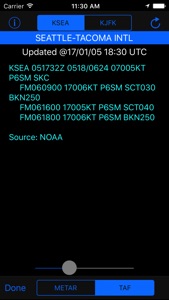
- Added METAR and TAF weather access.
1.1
June 24, 2011
- added user requested waypoint name to Favorite waypoint list.
- added help info screen to Aircraft and Favorite waypoint screen.
- added additional screen animations.
- added animations for Track and Distance units selections.
- minor bug fixes.
More1.0
June 14, 2011
Price History of FlyBy Nav
Description of FlyBy Nav
Flight planning is as easy as tapping in your point of departure, arrival and winds!
In one screen, FlyBy Nav displays track, heading, distance, ground speed, time enroute, ETA, and fuel burn.
- Fast database search and lookup of waypoints.
- Search function lets you search for an airport using its identifier, name or city name.
- Stores your favorite aircraft cruise performance numbers.
- Plots your great circle route on map.
- Quick Charter Quote feature.
- Track units in either Magnetic, True, or Grid
- Sunrise/Sunset and Azimuth feature.
- METAR and TAF weather access.
- 55,000 Airports and Navaids included (offline).
- Save your own user waypoints.
- No subscription charges.
Please visit our web site for more detail and screen shots of all the program features.
Show less
FlyBy Nav: FAQ
No, FlyBy Nav is not compatible with iPad devices.
Lonnie Ganz is the developer of the FlyBy Nav app.
The FlyBy Nav app currently supports iOS 12.0 or later.
With an overall rating of 5.0 out of 5, FlyBy Nav is a must-have app for users.
Navigation Is The App Genre Of The Flyby Nav App.
1.60 is the most recent version of FlyBy Nav.
The FlyBy Nav app was last updated on June 30, 2024.
FlyBy Nav was released on February 5, 2023.
Child-friendly content, no violence or scary images.
The FlyBy Nav app can be used in English.
Sorry, FlyBy Nav is not available on Apple Arcade.
Sorry, in-app purchases are not accessible within FlyBy Nav.
No, you cannot utilize FlyBy Nav with Apple Vision Pro.


