Live Reviews:
planlauf/TERRAIN

planlauf/TERRAIN

Displays 2D LiDAR maps

⭐️2.5 / 5
Rating
🙌2
Ratings
📼8 scs
Content
📦~ in 2 months
Updates frequency
🗣❌ unsupported
Your locale
🧾$0.99 - $11.99
In-App Purchase

All Versions of planlauf/TERRAIN

2.0.0

June 30, 2024

- New LiDAR map region: Rheinland-Pfalz / Germany - New LiDAR map region: Baden-Württemberg / Germany
More

1.8.6

July 10, 2023

- LiDAR map for Wales

1.8.4

January 21, 2023

- New LiDAR map region: Bayern / Germany

1.8.2

October 25, 2022

- Updated LiDAR map of England

1.8.0

September 26, 2022

- New LiDAR Map Region: Austria / Niederösterreich - Bugfixes

1.7.8

May 19, 2022

- Bugfix: Google Maps polygon sometimes appear purple - Bugfix: occasional crashes while deleting pins during track recording
More

1.7.6

February 11, 2022

- New LiDAR map region: Hessen / Germany

1.7.4

January 9, 2022

- Bugfix: sporadic crashes during import of maps on some devices

1.7.2

December 24, 2021

- Improved rendering when 'Load tiles during pan/zoom' is enabled

1.7.0

November 15, 2021

- Added 8000 km² to the LiDAR map of England - Haptic feedback (can be switched off in the settings) - Bugfix: ZoomFit in Google Maps not working when a 3D model is loaded - Bugfix: Find a place didn't work due to licensing issues
More

planlauf/TERRAIN In-App Purchases History

$0.99

Malta

LiDAR Map Malta

$7.99

Steiermark

LiDAR map region of Steiermark / Austria

$7.99

Tirol

LiDAR map region of Tirol / Austria

$7.99

Niederösterreich / Austria

LiDAR Map region of Niederösterreich/Austria

$7.99

Sachsen-Anhalt

LiDAR map region of Sachsen-Anhalt / Germany

$7.99

Hessen

LiDAR map region of Hessen / Germany

$10.99

Switzerland

LiDAR map region of Switzerland

$10.99

Bayern / Germany

LiDAR map region of Bayern / Germany

$11.99

LiDAR Map England

LiDAR Map Region England / UK

$11.99

LiDAR map Baden-Württemberg

LiDAR map for the region Baden-Württemberg

$11.99

LiDAR Map Rheinland-Pfalz

LiDAR map for the region Rheinland-Pfalz

Price History of planlauf/TERRAIN

Description of planlauf/TERRAIN

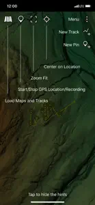
planlauf/TERRAIN's app for iOS displays 2D and 3D LiDAR maps that you can create with the desktop version of planlauf/TERRAIN. You can also purchase 2D LiDAR maps for some regions in Europe. Together with your device’s GPS, you can use the app for hiking or exploring landscapes.

planlauf/TERRAIN: FAQ

Does planlauf/TERRAIN offer an iPad version?

Yes, planlauf/TERRAIN has support for iPad devices.
planlauf GmbH released the planlauf/TERRAIN app.
The minimum supported iOS version for the planlauf/TERRAIN app is iOS 11.0.
Users have given planlauf/TERRAIN a so-so rating of 2.5 out of 5.
The Main Genre Of The Planlauf/terrain App Is Navigation.
The latest version of the planlauf/TERRAIN app is 2.0.0.
The last update for planlauf/TERRAIN was on July 6, 2024.
planlauf/TERRAIN was first released on February 6, 2023.
This app is appropriate for all ages, with no offensive or inappropriate content.
planlauf/TERRAIN is available in American English, German (Germany).
Unfortunately, planlauf/TERRAIN is not on Apple Arcade.
Yes, planlauf/TERRAIN allows for in-app purchases to enhance your experience.
No, you cannot use planlauf/TERRAIN with Apple Vision Pro.

Screenshots of planlauf/TERRAIN

iphone
ipad

Alternatives to planlauf/TERRAIN

Reviews of planlauf/TERRAIN

  • Useless.

    App requires specialized maps (the recruitment info doesn’t say this) and doesn’t tell you howto obtain such maps. I found it to be absolute useless.

    Developer Response

    Dear Zafarrano Wolffe, the info text states quite clearly that you can use the app to display 2D LiDAR maps created with the desktop version of planlauf/TERRAIN. You can get more info about the software here: https://planlaufterrain.com/