Live Reviews:
BRMB Maps by Backroad Maps

BRMB Maps by Backroad Maps

Trails, Fish, Hunt, Camp, Ride

⭐️4.2 / 5
Rating
🙌13
Ratings
📼10 scs
Content
📦~ in 1 month
Updates frequency
🗣❌ unsupported
Your locale
🧾$3.99 - $44.99
In-App Purchase

All Versions of BRMB Maps by Backroad Maps

3.0.1

June 14, 2024

Immerse yourself in the new 3D View, Directions, and Improved Maps in version 3.0! - NEW 3D View (try it with Satellite mode for a real-world experience!) - NEW Directions to All POIs - Cartography improvements to Roads and Cities - Updated POI Activities - Additional bug fixes Plus, Version 3.0 also introduces our new price structure. New users can now choose between our yearly and monthly plan
More

3.0.0

June 5, 2024

Immerse yourself in the new 3D View, Directions, and Improved Maps in version 3.0! - NEW 3D View (try it with Satellite mode for a real-world experience!) - NEW Directions to All POIs - Cartography improvements to Roads and Cities - Updated POI Activities - Additional bug fixes Plus, Version 3.0 also introduces our new price structure. New users can now choose between our yearly and monthly plan
More

2.5.0

May 8, 2024

Version 2.5 focuses on upgrading our core mapping framework to support more advanced mapping functionality in the future. This version also offers a better map viewing experience. - Upgraded our core mapping framework for a more optimized viewing experience - Includes Faster Rendering of maps - Rebuilt our Offline Maps system for recording areas for Off-the-Grid use* - Addressed Tracking issues - Additional Bug Fixes *Current BRMB Maps users please note that new Offline Maps must be created and saved.
More

2.4.0

December 16, 2023

Version 2.4 includes a major update of all basemap and Adventure information, bringing in all of the changes and updates over the last year. The basemap has over 22,000 km of new and updated roads plus over 8,000 new land and water features. The Adventures includes over 20,000 km of new and updated ATV/Overland/Snowmobile, Multi-Use/Mountain Bike and Paddling Routes and Trails. There are also 5,400 new Adventure POI added. We were also able to fit in a new Quick Start track recording as well as new colour line styles to help differentiate the various recorded tracks by activity. Version 2.4 Highlights: - Includes hundreds of customer Map and POI Updates from the 30th  Anniversary Contest - Includes tens of thousands of km of new roads, thousands of km of new ATV and snowmobile routes, multi-use and bike trails, paddling routes and more. - Includes over 8,000 new Land and Water features - Includes almost 5,500 new Adventure POIs - Enhanced Private/Crown Land, Industry/Rec Roads, Oil & Gas, Service Providers, Gas Stations and EV Charging Overlays - Autofill date/time and activity to help start recording your tracks quicker - Track lines are now coloured by outdoor activity to help you differentiate between your favourite activities Version 2.4 Update Stats: - 17,000+ km of various roads & highways - 5,000 km of new or enhanced Logging Roads - 10,000 km of additional ATV Trails - 1,500 km of Overland Routes - 650 km of new Snowmobile Trails - 6,000 km of new and updated Multi-use Trails - 250 km of new Mountain Bike Trails - 2,000 km of new and enhanced Paddling Routes - 8,000 new Land & Water features POIs - 5,400 more Adventure POIs
More

2.3.1

October 28, 2023

Version 2.3 focuses on improving the Hunting information with new layers for the main Big Game species hunted across Canada. The addition of the Restricted Areas layer, along with the Wildfire Areas layer, not only helps hunters but also helps all Recreationists know where there are motorized closures and recent wildfire activity. - A new Hunting layer featuring the 12 main Big Game Species pursued across Canada - Includes hundreds of Hunting Draw POIs and boundaries across Canada - Improved links to Hunting Regulations and Licensing - Improved Hunting and Fishing Tips and Tricks - A new Wildfires layer with current and historical Wildfire Areas - A new Restricted Areas layer featuring BC Section 58 Closures, Wildlife Act Motorized Restrictions, Watersheds and more! - Additional Bug Fixes Don’t miss out, this is the final month to enter the BRMB Maps 30th Anniversary Contest. Visit www.BRMBmaps.com/adventure-challenge to enter and win prizes while exploring the Canadian Outdoors.
More

2.3.0

September 26, 2023

Version 2.3 focuses on improving the Hunting information with new layers for the main Big Game species hunted across Canada. The addition of the Restricted Areas layer, along with the Wildfire Areas layer, not only helps hunters but also helps all Recreationists know where there are motorized closures and recent wildfire activity. - A new Hunting layer featuring the 12 main Big Game Species pursued across Canada - Includes hundreds of Hunting Draw POIs and boundaries across Canada - Improved links to Hunting Regulations and Licensing - Improved Hunting and Fishing Tips and Tricks - A new Wildfires layer with current and historical Wildfire Areas - A new Restricted Areas layer featuring BC Section 58 Closures, Wildlife Act Motorized Restrictions, Watersheds and more! - Additional Bug Fixes Don’t miss out, this is the final month to enter the BRMB Maps 30th Anniversary Contest. Visit www.BRMBmaps.com/adventure-challenge to enter and win prizes while exploring the Canadian Outdoors.
More

2.2.1

August 25, 2023

Version 2.2 has a nautical feel with the addition of BC Marine Trails, enhanced Paddling and Fishing Adventures, new Lake and Ocean Bathymetry, and a new Diving Adventures layer. In addition, we have enhanced and expanded the Parks & Camping Adventures and Service Providers, while adding the ability to highlight selected Tracks when viewing on the Map. · New BC Marine Trails with Launch Sites, Day Use Sites, Campsites, Emergency Pullouts, and more! · New Diving Adventures layer · New Ocean Bathymetry added to all Canadian coastlines · Enhanced Paddling Adventures with Access Locations and Put In/Take Outs · Enhanced Fishing Adventures with Boat Launches and Marinas · Added Lake Bathymetry in NL, MB, ON, and BC · Updated our Parks Adventures with more Campgrounds, Picnic Areas, and more! · Enhanced our Service Providers with Resorts, Visitors Centres, and more! · Highlight individual selected Tracks when viewing on the Map · Additional Bug Fixes Be sure to enter the BRMB Maps 30th Anniversary Contest. Visit www.BRMBmaps.com/adventure-challenge to enter and win prizes while exploring the Canadian Outdoors.
More

2.2.0

July 20, 2023

Version 2.2 has a nautical feel with the addition of BC Marine Trails, enhanced Paddling and Fishing Adventures, new Lake and Ocean Bathymetry, and a new Diving Adventures layer. In addition, we have enhanced and expanded the Parks & Camping Adventures and Service Providers, while adding the ability to highlight selected Tracks when viewing on the Map. · New BC Marine Trails with Launch Sites, Day Use Sites, Campsites, Emergency Pullouts, and more! · New Diving Adventures layer · New Ocean Bathymetry added to all Canadian coastlines · Enhanced Paddling Adventures with Access Locations and Put In/Take Outs · Enhanced Fishing Adventures with Boat Launches and Marinas · Added Lake Bathymetry in NL, MB, ON, and BC · Updated our Parks Adventures with more Campgrounds, Picnic Areas, and more! · Enhanced our Service Providers with Resorts, Visitors Centres, and more! · Highlight individual selected Tracks when viewing on the Map · Additional Bug Fixes Be sure to enter the BRMB Maps 30th Anniversary Contest. Visit www.BRMBmaps.com/adventure-challenge to enter and win prizes while exploring the Canadian Outdoors.
More

2.1.2

June 14, 2023

Version 2.1 continues on the FRESH NEW LOOK and feel, while adding in new layers for Overlanders and Oil & Gas & other Industrial features. We have also enhanced the Snowmobile Layer with BC Riding Areas and Closures, and BC Ski Areas also have new area boundaries, chairlifts and ski runs. - New Help Guide & App Tour - Updated Tools Menu - Added a Your Data section with Stats and KMs of Tracks completed - New Overland Adventure Layer for long distance touring on ATV, 2WD/4WD, Dual Sport Bike or Snowmobile! - 150,000+ Resource POIs including Wellsites, Compressor Stations, Plants, Gates and more! - Thousands of Industry Pipelines, Cutlines, Wellsite Footprints, Pipeline Corridors and more! - Trail Adventures now include Unclassed Trails - Snowmobile Riding Areas and Closures - Ski Resorts, Chairlifts, Downhill and Backcountry Ski Runs Be sure to enter the BRMB Maps 30th Anniversary Contest. Visit www.BRMBmaps.com/adventure-challenge to enter and win prizes while exploring the Canadian Outdoors.
More

2.1.1

June 7, 2023

Version 2.1 continues on the FRESH NEW LOOK and feel, while adding in new layers for Overlanders and Oil & Gas & other Industrial features. We have also enhanced the Snowmobile Layer with BC Riding Areas and Closures, and BC Ski Areas also have new area boundaries, chairlifts and ski runs. - New Help Guide & App Tour - Updated Tools Menu - Added a Your Data section with Stats and KMs of Tracks completed - New Overland Adventure Layer for long distance touring on ATV, 2WD/4WD, Dual Sport Bike or Snowmobile! - 150,000+ Resource POIs including Wellsites, Compressor Stations, Plants, Gates and more! - Thousands of Industry Pipelines, Cutlines, Wellsite Footprints, Pipeline Corridors and more! - Trail Adventures now include Unclassed Trails - Snowmobile Riding Areas and Closures - Ski Resorts, Chairlifts, Downhill and Backcountry Ski Runs Be sure to enter the BRMB Maps 30th Anniversary Contest. Visit www.BRMBmaps.com/adventure-challenge to enter and win prizes while exploring the Canadian Outdoors.
More

BRMB Maps by Backroad Maps In-App Purchases History

$3.99

BRMB Maps PRO

Unlock All BRMB Adventures and Offline Maps

📈 increased from $2.49 to $3.99 on June 30, 2024

$6.99

BRMB Monthly PRO Access

Access the PRO Overlays and Offline Maps

$44.99

BRMB Yearly PRO Access

Access the PRO Overlays and Offline Maps

Price History of BRMB Maps by Backroad Maps

Description of BRMB Maps by Backroad Maps

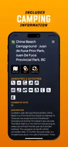
Experience the Great Outdoors of Canada in a whole new way with BRMB Maps' top-rated backcountry maps. Our industry-leading road and trail maps cover all of Canada, and our Smartphone App and Web Map let you research, plan and navigate with ease – even offline! Our maps are complemented with thousands of points of interest for outdoor recreation, including hunting, fishing, camping, hiking, biking, canoeing, kayaking, ATVing, snowmobiling, skiing, snowshoeing, and wildlife viewing. Plus, our descriptions and data are unlike anything you will find in other mapping apps, making BRMB Maps the ultimate tool for backcountry exploration. The BRMB Maps App is a one stop guide, allowing for safe and easy navigation into and out of the Canada’s backcountry: View your current location on the map and track your route The fast, seamless map interface allows you so see all the roads, parks, and geographic features from the popular Backroad Mapbooks series across the entire country. Reveal the lay of the land with topographic contours and relief shading Explore lakes like never before with bathymetric (lake depths) contours Zoom in and see all the logging, industrial and other roads not found on other maps View on multiple devices, such as smartphone tablet or computer, with a single account GET MORE WITH BRMB MAPS PRO Download offline maps - track your exact GPS location as you navigate the trail, even when you don’t have a signal Save All the info offline - even Point of Interest information & descriptions Access current, high resolution satellite map imagery Adventure Layers revealing thousand’s of Points of Interest within each Adventure Layer providing descriptions, access, trail info, fish and hunt species, and so much more Access Crown Land and Private Land Layers Access the Resource and Recreation Road layer to overlay on the satellite imagery Record your Adventures & Save your Trips Get access to the BRMBMAPS.COM website, where you can further plan your trips and explore on a bigger screen Design and print custom topo maps through brmbmaps.com Adventure Layers include: Attractions - Over 15,000 Attractions, Beaches, Caves, Ghost Towns, Hot Springs, Lighthouses, Museums, Waterfalls, and more Fishing - Over 20,000 Lake, River & Creek and Ocean Fishing areas - Fish Zone Boundaries, Lake Bathymetry, Stocked Lakes, Marinas & Boat Launches - Fishing descriptions with Species, Lake Stats & Regulation links Hunting Areas - Over 2,500 Management Units (WMU/WMZ, etc.), Species Specific Zones, and more - Hunting descriptions with Species & Regulation links Paddling Routes - Almost 3,000 Paddling routes including Access Points & Portages - Canoe & Kayak, Lake Circuits, River & Ocean Routes and Whitewater Parks - Over 35,000 National, Provincial, Regional & Urban parks including Campsites, Picnic Areas, Backcountry Cabins, Conservation Areas, and more Recreation Sites - Over 1,300 sites listed with Activities, Size, RV or 4wd Access, and more Trails - Over 14,000 Trail tracks with Trailheads for Hiking, Biking, Equestrian, and more - Trail descriptions including Difficulty, Length and Elevation Gain ATV Trails - Almost 1,700 trail tracks with Trailheads for ATV, OHV, Dirtbikes and Overlanding Snowmobile Routes - Over 2,250 trail tracks with Trailheads offering Club, Groomed & Backcountry Routes Wildlife Viewing - Over 1,750 sites for Birdwatching, Large & Small Animals, Whale Watching, and more Winter Recreation - Over 1,900 Trail tracks with Trailheads for Backcountry, Cross-Country & Nordic Skiing, Downhill Areas, and Snowshoeing BRMB Maps PRO is only $3.49/mo. Payment will be charged to your iTunes account on confirmation. Subscriptions will automatically renew unless cancelled within 24-hours before the end of the current period. You can turn-off auto-renewal in Settings: http://support.apple.com/kb/ht4098 Our Terms of Use: https://www.brmbmaps.com/terms-conditions Our Privacy Policy: https://www.brmbmaps.com/privacy-policy
Show less

BRMB Maps by Backroad Maps: FAQ

Is there an iPad version available for BRMB Maps by Backroad Maps?

Yes, BRMB Maps by Backroad Maps is compatible with the iPad.
BRMB Maps by Backroad Maps was created by Mussio Ventures Ltd..
The minimum iOS requirement: 13.0.
Users love BRMB Maps by Backroad Maps, as evidenced by its outstanding rating of 4.2 out of 5.
The App Genre Of Brmb Maps By Backroad Maps Is Navigation.
The latest version of BRMB Maps by Backroad Maps is 3.0.1.
BRMB Maps by Backroad Maps’s latest update was rolled out on July 4, 2024.
The app was launched on February 5, 2023.
Family-friendly content, no mature themes or violence.
The BRMB Maps by Backroad Maps app is now available in American English.
Unfortunately, BRMB Maps by Backroad Maps is not on Apple Arcade.
Absolutely! In-app purchases are available within BRMB Maps by Backroad Maps.
Unfortunately, BRMB Maps by Backroad Maps is not optimized for use with Apple Vision Pro.

ASO: Keywords of BRMB Maps by Backroad Maps

Screenshots of BRMB Maps by Backroad Maps

iphone
ipad

More Applications by Mussio Ventures Ltd.

Alternatives to BRMB Maps by Backroad Maps

Reviews of BRMB Maps by Backroad Maps

  • Americans Don’t Use This

    I live in Texas and when I loaded up the app, nothing showed. Nothing showed for the entire United States. The only area that had any detail was Canada. So if you live in the US there is not point in getting this app.