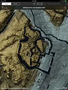
東京時層地図 for iPad

東京時層地図 for iPad

$20.99
Buy now
Rating summary

Details about 東京時層地図 for iPad

  • Released
  • Updated
  • iOS Version
  • Age Rating
  • Size
  • Devices
  • Languages
  • June 7, 2016
  • October 1, 2024
  • 9.0+
  • 4+
  • 1.84GB
  • iPad
  • English
    Japanese

Developer of 東京時層地図 for iPad

🙌0
Ratings
🗣❌ unsupported
Your locale
🖼️Download
Icons↘︎

Version History of 東京時層地図 for iPad

1.2.1

July 19, 2018

This app has been updated by Apple to display the Apple Watch app icon. Fix issue of map infomation view.

More

1.2.0

June 8, 2018

- Supporting for iPad Pro. - Added new aerial photo layer "1936 (GSI)". - Added English language to user interface.

More

1.1.0

March 11, 2016

-Add "GSI Maps", shows aerial photography from various eras.

1.0.1

October 1, 2014

Fix issues with iOS8.

1.0.0

November 6, 2013

Price History of 東京時層地図 for iPad

Description of 東京時層地図 for iPad

"Jisou" means "layers of time." The maps and aerial photographs in this app show Tokyo at different moments in the past. "Tokyo Jisou Maps" is a map application program that can learn the transition from the Meiji era to the present age. "Tokyo Jisou Maps for iPad" is a special application for iPad that provides the transition of a city over time. This application includes the areas covered by both "Tokyo Jisou Maps" and "Yokohama Jisou Maps". With this application, a user can view the maps of the major cities of Japan such as Tokyo, a capital of Japan, Yokohama and Kawasaki at different time periods such as the Meiji, Taisho, Showa and Heisei eras. This iPad-special application has the following functions which iPhone application does not have. (Function Added) - Capable to display 2 screens - Bookmarking function (capable for SNS) - Retrieval function for place names Using a larger display of iPad, a user can explore the transitions of a city by juxtaposing both an old map of 6 time periods and a present map or an aerial photograph. A user can also enjoy walking around an old city using GPS function. Six time periods are the civilization and enlightenment period, the end of the Meiji era, just before the Kanto Great Earthquake, the time before the WWII, just before the high economic growth before the bubble economy and the present days. As a capital of Japan, Tokyo is developing as a cosmopolitan city with concentration of various functions such as politics, economy, culture, population etc. Particularly after the rapid economic growth, Tokyo has made a remarkable development and urbanization had rapidly progressed. Tokyo Olympic of 1964 pushed further the urbanization and modernization of Tokyo and provided momentum for developing infrastructures such as Shinkansen(a high-speed rail), expressways, a monorail, etc. Whereas, Yokohama has been developing as a gateway of port since the arrival of Kurofune (the black ships of Commodore Matthew Perry). With foreign trading houses and settlements, the city with an exotic atmosphere was formed. Presently, Yokohama has developed as one of the international trading cities. These changes were firmly stamped on an old maps and a user can think about old days with laying old map over the present map. You can reconsider ever-changing cities of Japan using this application. Knowing the past enables you to see enjoyable future.
Show less

東京時層地図 for iPad: FAQ

Does 東京時層地図 for iPad work on iPads?

Yes, 東京時層地図 for iPad can be used on iPad devices.

Who developed the app?

Japan Map Center, Inc. developed the 東京時層地図 for iPad app.

What minimum version of iOS does 東京時層地図 for iPad need?

To function properly, the app requires at least iOS 9.0.

What do users think of the 東京時層地図 for iPad app?

Currently, the 東京時層地図 for iPad app has no user ratings.

What category of app is 東京時層地図 for iPad?

The 東京時層地図 For Ipad App Relates To The Navigation Genre.

What is the recent version of 東京時層地図 for iPad?

1.2.1 is the newly released version of the 東京時層地図 for iPad app.

What is the date of the most recent 東京時層地図 for iPad update?

October 1, 2024 is the exact date of the latest 東京時層地図 for iPad update.

What is the specific date when the app came out?

The 東京時層地図 for iPad app became available to the public on March 26, 2023.

What age is 東京時層地図 for iPad suitable for?

Japan Map Center, Inc.: The 東京時層地図 for iPad app is child-friendly.

What are the languages offered by the 東京時層地図 for iPad app?

東京時層地図 for iPad can be used in English, Japanese.

Does Apple Arcade offer 東京時層地図 for iPad as part of its collection?

No, 東京時層地図 for iPad is not featured on Apple Arcade.

Can I make in-app purchases within 東京時層地図 for iPad?

No, 東京時層地図 for iPad does not include options for in-app purchases.

Is 東京時層地図 for iPad specifically engineered for Apple Vision Pro compatibility?

Sorry, 東京時層地図 for iPad is not specifically engineered for compatibility with Apple Vision Pro.

Are there commercial ads in 東京時層地図 for iPad?

No, there are no commercial ads in 東京時層地図 for iPad.

Screenshot of 東京時層地図 for iPad

東京時層地図 for iPad screenshot #1 for iPad
東京時層地図 for iPad screenshot #2 for iPad
東京時層地図 for iPad screenshot #3 for iPad
東京時層地図 for iPad screenshot #4 for iPad
東京時層地図 for iPad screenshot #5 for iPad
ipad

Alternatives to 東京時層地図 for iPad

More Applications by Japan Map Center, Inc.