SeaNav

SeaNav

Marine Charts and Navigation

Details about SeaNav

  • Released
  • Updated
  • iOS Version
  • Age Rating
  • Size
  • Devices
  • Languages

Features

Developer of SeaNav

🙌199
Ratings
🗣❌ unsupported
Your locale
🖼️Download
Icons↘︎

Version History of SeaNav

5.4.9

June 12, 2024

UI Improvements and fixes -Quick Link to Boat Beacon button added (top right) - Boat Beacon also has a quick link back to SeaNav -Request to launch Boat Beacon on start sailing now defaulted to not show( re-enable in Advanced settings or just use the new Boat Beacon quick link button). -iPhone landscape mode now displays current time again -iPad instruments side panel in landscape displays time -SART TEST targets no longer fire an alarm -Weather map now scrolls up and down -French . German & Spanish language support added

More

5.4.8

May 30, 2024

Added Watch complication for SeaNav so you can launch SeaNav from the clock face. Fix for instruments crashing when dismissed on iPhone

5.4.7

May 16, 2024

Fix for viewing routes on older iPads on pre iOS16.

5.4.6

March 28, 2024

Fixes and Updates for latest iPad iOS support.

5.4.5

October 19, 2023

Charts for the whole of France and Portugal now available Fix for start up problems on iOS 17 when trying to load the charts.

5.4.4

August 15, 2023

Charts for the whole of France and Portugal now available Fix for updatable charts that have not been updated not displaying if SeaNav is not connected to the internet.

More

5.4.3

April 26, 2023

DE,DK and NL demo routes and charts added Multilignual support for UserGuide and FAQ My Boat Details type can now be set - e.g. Sailing, Fishing, Pleasure, Diving etc. Easier to see My Boat icon with boat type colour Bridges, Shoreline and Traffic zones UI improvements Fix for S.Cardinal light patterns User guide and FAQ can now be read when offline too Fix for route traversing international dateline

More

5.4.2

March 15, 2023

Trial charts and routes added for Denmark, Germany and the Netherlands. User guide and FAQ now available in multiple languages. My Boat Details now lets you set the type - e.g. Sail, Pleasure, Fishing. Own boat icon now bigger so more easily viewed and colour shows boat type. Bridges, Shoreline and Traffic zones UI improvements Flashing light patterns updated for South Cardinals

More

5.4.1

July 5, 2022

stability improvements

5.4

April 6, 2022

Apple Watch App greatly improved Nav, Waypoint, Map ,CPA Alerts & new real time wind display Realtime local wind instrument using SeaNav's Weather feed (IAP) or NMEA over Wifi Improved Instruments for Nav (inc. Depth), Waypoints & Wind Export tracks and routes as GPX (e.g to MFDs, Chart plotters and Navionics) Export and import all POIs Settings for Auto/Day/Night mode display iOS15 ready

More

SeaNav In-App Purchases History

$14.99

Pro Features

Add AIS ships layer with photographs and full ship's details, a live camera AR Overlay View and ActiveCaptain's Marinas, Anchorages, Info and Hazards to enrich your SeaNav experience

More

SeaNav Subscription Plans

Weather charts

Current and forecast for the next 10 days

$4.991 Year

New Zealand Charts

Official New Zealand marine raster charts

$5.991 Year

NOAA US Raster Charts

Add NOAA navigational charts (NOAA RNC®) with full-color digital images of NOAA paper charts for the whole of the US including the Great Lakes. Includes automatic chart updates from NOAA.

$9.991 Year

Pro Features

Internet AIS & Augmented Reality

$10.491 Year

US Charts

NOAA digital charts with a year of updates

$19.991 Year

French Charts

Charts for the whole of France & Corsica

$22.991 Year

Spanish Charts

Official Marine Vector charts for the whole of Spain including one year of chart updates.

$22.991 Year

UK & IE Charts

Get the latest UKHO digital vector charts for UK and Ireland with a year of updates including new charts from the SeaNav Chart service.

$24.991 Year

Canadian Charts

Marine charts for the whole of Canada including the Canadian Great Lakes

$26.991 Year

Price History of SeaNav

Description of SeaNav

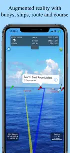
Explore, plan and navigate your boating trips in real time and outstanding high-resolution using digital charts derived from the latest NOAA and UKHO data providing coverage across the US and Europe (US, CA, UK & IE, DE, FR, NL, BE, DK, NO,ES,HR,PT). Raster charts for US, NZ, FI & EE. - Vector charts - all buoys, lights etc. are tappable - Seamless fast panning and zoom across charts - Route Planning and real-time tracking - North up and course up displays - Offline charts - Configurable layers - Built-in tutorial mode with full features including charts, AIS, AR & wind - Tides, Streams & Weather - Live AIS Ship positions and collision alarm (IAP) - Import and share routes and POIs in GPX and KML formats via email and Dropbox - Live Augmented Reality camera view (IAP) plus FLIRONE® night vision support. - Includes free Apple Watch app with Nav,Waypoint,Wind,AIS faces. - NMEA Depth, Wind Speed and Direction - Real time local wind feed (IAP) The free version includes all navigation and trip planning tools. High resolution vector charts are available by In App Purchase (IAP) including updates for 12 months. Vector charts provide many advantages over traditional raster charts. Buoys, Lights, Bridges, Depth Contours, Depth Soundings, Rocks, Anchorage areas, NOAA Weather Buoys etc. are all selectable and have real time distance, bearing and detail information. Turn off layers to de-clutter the display and only show what is important at the time. Tides, moon and sun times and weather are also all available at your fingertips. In-app tools let you measure distances and bearings and record waypoints on routes to sail. When you are out at sea, the app’s Sailing HUD shows your position on the route, Course over ground (COG), Speed over ground (SOG), Vector Made Good (VMG), Estimated Time of Arrival (ETA), Distance and bearing to next Waypoint. Waypoint reached alerts, auto-routing to the next waypoint and flashing collision alerts (with AIS). Unique AR view mode (IAP) allows you to view buoys, lights, ships, waypoints, route and track overlaid on your iPhone or iPad live camera view. With "AR LockOn" you can select a target on the chart and then be guided to it in the AR camera view. You can also see at night and in the fog with the FLIRONE Infra-red camera. External NMEA GPS, AIS and Wind data over Wifi. Requirements: GPS only required for real time route navigation. Optional Real time AIS, Tides and Weather information require an active internet connection. WiFi-only iPad or iPods will need an external GPS receiver for navigation. Please note that continued use of GPS running in the background can dramatically decrease battery life. Subscriptions Our in-app purchases are 1 year subscriptions, which automatically renew at the end of the subscription period unless auto-renew is turned off at least 24-hours before the end of the current period. Payment will be charged to your iTunes Account at confirmation of purchase, and will be charged for renewal within 24-hours prior to the end of the current period. Pricing for our 1 year US Charts update subscription is $19.99. Subscriptions may be managed by the iTunes account holder and auto-renewal may be turned off by going to Account Settings after purchase. 
No cancellation of the current subscription is allowed during active subscription period. NOTICES: This product has been derived in part from material obtained from the UK Hydrographic Office with the permission of the UK Hydrographic Office, Her Majesty’s Stationery Office.” “© British Crown Copyright, [2012]. All rights reserved. The UK Hydrographic Office (UKHO) and its licensors make no warranties or representations, express or implied, with respect to this product. The UKHO and its licensors have not verified the information within this product or quality assured it. Terms of Use: http://seanav.net/termsofuse.php Privacy Policy: http://seanav.net/privacy.php Support: help@pocketmariner.com
Show less

SeaNav: FAQ

Is SeaNav software compatible with iPad devices?

Yes, SeaNav is compatible with the iPad.

Who developed the SeaNav app?

The app was developed by Pocket Mariner Ltd..

What minimum version of iOS does SeaNav need?

SeaNav minimum iOS requirement is iOS 11.0.

What do users think of the SeaNav app?

Users love SeaNav, as evidenced by its outstanding rating of 4.3 out of 5.

What’s the genre of the SeaNav app?

The App Genre Of Seanav Is Navigation.

What is the latest version of SeaNav?

The latest SeaNav version released is 5.4.9.

What date was the latest SeaNav update released?

SeaNav’s latest update was rolled out on September 29, 2024.

What is the exact date the SeaNav app came out?

The app was launched on February 6, 2023.

What is the content advisory rating for the SeaNav app?

Family-friendly content, no mature themes or violence.

What languages does the SeaNav app support?

The SeaNav app is now available in Danish, English, French and 2 more.

Can I play SeaNav through Apple Arcade's subscription?

Unfortunately, SeaNav is not on Apple Arcade.

Does SeaNav offer in-app purchases?

Absolutely! In-app purchases are available within SeaNav.

Is SeaNav optimized for use with Apple Vision Pro?

Unfortunately, SeaNav is not optimized for use with Apple Vision Pro.

Does SeaNav incorporate ads within the app?

No, SeaNav does not incorporate ads within the app.

Video & Screenshots of SeaNav

SeaNav video #1 for iPhone
SeaNav screenshot #2 for iPhone
SeaNav screenshot #3 for iPhone
SeaNav screenshot #4 for iPhone
SeaNav screenshot #5 for iPhone
SeaNav screenshot #6 for iPhone
SeaNav screenshot #7 for iPhone
SeaNav screenshot #8 for iPhone
SeaNav screenshot #9 for iPhone
SeaNav screenshot #10 for iPhone
SeaNav screenshot #11 for iPhone
iphone
ipad
watch

Alternatives to SeaNav

More Applications by Pocket Mariner Ltd.

Reviews of SeaNav

Leave a Review SeaNav
  • Question

    Can you see water depth on Apple Watch ?

    Developer Response

    Hi, Thanks fory your rating and question. We are hoping to add a Depth watch face for the next release. It will show the current depth (either from NMEA depth sounder or chart depth) and the depth history for the last 30 minutes ( for contour tracking). If you have any other suggestions for the depth display please let us know. The PocketMariner crew
  • Awesome tool

    This has to be one of the best tools to have in your hands.

    Developer Response

    Thank you very much for a lovely review. Fairwinds The PocketMariner crew
  • Misleading marketing do not buy

    They do not make it clear that chart purchases are required. To make it even more misleading I can’t use the charts Boat Beacon which I already purchased from them. There was a link in Boat Beacon to SeaNav saying I could navigate with SeaNav and show AIS overlays on the charts. Well now they want me to repurchase the charts I already bought from them
    Show less

    Developer Response

    Hi, Sorry to hear you are having problems with accessing the charts in SeaNav. Could you please contact us at help@pocketmariner.com so we can sort out the charts availability for you in SeaNav?